| Services
: Airfield Obstruction
Surveys |
Airport Obstruction Chart Surveys are
a necessity for the operations of the National Airspace
System. These surveys are an accurate catalog of
vertical obstructions to runway approaches. They also
serve to maintain the reliability of airport information
available to pilots. Using Obstruction Identification
Surfaces (OIS) and stereo imagery, Triangle Aerial Surveys
is able to pinpoint and collect these obstructions. For
the purpose of establishing safe glide slopes to an airport’s
runways, any object that penetrates the OIS, as well
as the highest object in a given area, is considered
an obstruction. In addition to this dataset, planimetric
features such as the runway, airfield structures and
navigational aids are also collected.
The ClearFlite
module in BAE’s Socet Set is able to create automatically
Obstruction Identification Surfaces conforming to NOAA,
FAA, and NGS standards. Using these surfaces as a reference,
the program tracks cursor movement as operators inspect
the aerial imagery. ClearFlite informs the operator when
his cursor penetrates the OIS, allowing for quick and accurate
collection of obstruction features. ClearFlite also helps
the operator keep track of which surface he is currently
working in, as well as specialized values such as the distance
of an obstruction from the end of the runway.
The Feature Extraction module for
Socet Set makes the collected data available for direct access through CADD and
GIS applications. In addition to the
obstruction features collected through Clearflite, the Feature Extraction toolset
enables the operator to collect planimetric and other major identifiable features
around the airfield. These features help those analyzing the data to determine
effectively the locations of objects and structures of significance. |
| |
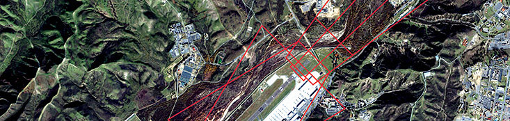
Sample Project:
Hickory Regional Airfield Obstruction Survey,
Hickory NC
 Utilizing BAE Socet Set’s Clear Flite module,
Triangle Aerial Surveys is able to perform Airfield Obstruction
Surveys for airports big and small. Hickory Regional
Airport (HKY) located in Hickory, North Carolina was
an Airfield Obstruction Survey to be performed on-site
at TAS. Utilizing BAE Socet Set’s Clear Flite module,
Triangle Aerial Surveys is able to perform Airfield Obstruction
Surveys for airports big and small. Hickory Regional
Airport (HKY) located in Hickory, North Carolina was
an Airfield Obstruction Survey to be performed on-site
at TAS.
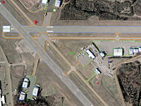
Individual surfaces adhering to ANA standards
were created for each runway. Planimetric features
were then collected within a Socet Set Feature Database. Airport
features including all buildings, taxiways, aprons, and
navigational aids were stereoscopically collected from
multispectral aerial photography. All transmission
lines that were in the approach surface were collected. Finally
any feature the operator deemed important, such as major
roads, water bodies and buildings, were also collected
as part of the planimetric features.
Once all the
desired planimetric features were collected each obstruction
surface was carefully reviewed. The
highest features as well as the features that penetrate
the obstruction surface most in the photographs were
recorded for the approach, primary, transitional and
missed approach surfaces for each runway. Special
attention was paid to transportation lines, vegetation
and buildings that fall within the obstruction surfaces. The
resulting Feature Database was double checked by the
quality assurance team before meeting final approval.
|
|
|