Services
: |
Resource
Management & Data Analysis |
GIS Applications
Geographic Information Systems (GIS) cover a wide selection of possible applications.
The versatility of GIS has made it a popular choice for data collection, storage,
and presentation. Employing highly-experienced GIS professionals, Triangle
Aerial Surveys (TAS) is ready to provide these services. |
| |
Custom GIS Applications
Using concepts and tools in GIS, data from various sources are correlated for
display over a geographic platform. The functionality of data layers streamline
on-demand access to the data that the client needs at a particular moment. Visualization,
database queries and cross-references are made simple and clean with a single,
condensed information source. |
| |
Data Conversion
In many cases, data must first be re-formatted
before its usefulness is fully realized. Triangle
Aerial Surveys offers many data conversion solutions,
including:
• Conversion between CADD formats (Dwg,
Dxf, Dgn)
• Conversion of digital imagery files
to different formats (Tiff, jpg, MrSid, EPS)
• Conversion
of CADD data to GIS formats (SHP)
• Visual
representation of a database in a GIS environment
• Digitization of raster information
to a scalable vector format |
| |
Database Management
Existing databases may have information that is outdated or no longer applicable.
Triangle Aerial Surveys can offer the solution. New data, supplied by the client
or collected from other sources, can update a database. Services can also
be rendered and monitored on an ongoing basis to ensure the most current and
accurate information accessible to the client. |
| |
Volumetric Analysis
DEM and DTM data from lidar or stereo-compilation can be used for volumetric
analysis of a site. Landfills, quarries and stockpiles are areas that change
often in short periods of time, requiring constant updating and time-sensitive
record-keeping. Triangle Aerial Surveys serves waste management, mining and power
companies with accurate and time-efficient volumetric calculation and analysis
that could be easily tracked in a geodatabase.
|
| |
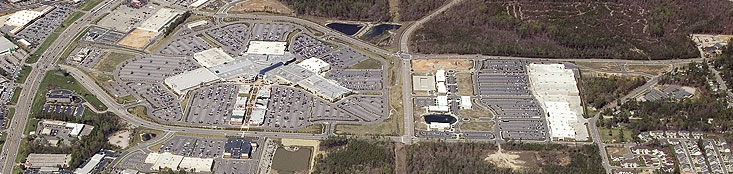
Sample Project:
Project Kinston Plant
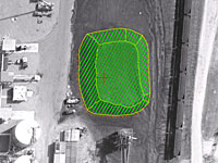 Triangle
Aerial Surveys completed a volumetric analysis
project for the Kinston Plant in North Carolina. TAS
performed the aerial mission and acquired the
aerial photography. Existing ground control
was re-paneled for the project. Using a
compiled Digital Terrain Model (DTM) and generated
1’ contours, TAS calculated the volume
of the plant’s coal pile. Triangle
Aerial Surveys completed a volumetric analysis
project for the Kinston Plant in North Carolina. TAS
performed the aerial mission and acquired the
aerial photography. Existing ground control
was re-paneled for the project. Using a
compiled Digital Terrain Model (DTM) and generated
1’ contours, TAS calculated the volume
of the plant’s coal pile.
|
| |
Sample Project:
Catawba Layer Update, Catawba
County, NC
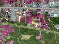 This
project was a GIS update of the Impervious Surfaces
Layer for Catawba County in North Carolina. The
existing layer was created in 1998 and was in
need of revision. Orthophotos taken from
2005 in MrSID format were used as reference for
the project for heads-up classification along
with files from the county showing commercial
and industrial areas in particular that needed
to be updated. All polygon updates and
recalculations of land use were performed in
ArcGIS dividing the land into sixteen different
land use codes. This
project was a GIS update of the Impervious Surfaces
Layer for Catawba County in North Carolina. The
existing layer was created in 1998 and was in
need of revision. Orthophotos taken from
2005 in MrSID format were used as reference for
the project for heads-up classification along
with files from the county showing commercial
and industrial areas in particular that needed
to be updated. All polygon updates and
recalculations of land use were performed in
ArcGIS dividing the land into sixteen different
land use codes.
|
| |
|
|
|