| Services
: Photogrammetric |
Topographic and Planimetric Mapping
Geographic and cultural
features compiled from aerial photographs and remote sensing
data provide a practical alternative to the conventional
ground survey methods in the mapping of large sites. Planimetric
maps, which show the relationships between features at
a specified map scale, are useful for applications such
as golf course maintenance and GIS base maps. When accurate
elevation information is required, topographic maps can
be created with contour intervals that reflect client requirements.
TAS operates state of the art Dat/Em Summit Evolution
softcopy workstations to extract planimetric and topographic
features, and an array of software tools for generating
and processing contours, map formats and symbols. |
| |
Sample Project:
Project 05045 Carolina Village
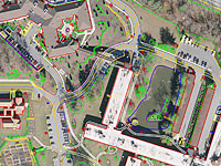 TAS
was responsible for acquiring color aerial imagery
for orthophotography and topographic and planimetric
mapping. The area covering approximately half of a
mile was photographed at a low altitude in order to
achieve the specifications appropriate for a map scale
of 1”=50’. Planimetric data was collected
from stereo imagery. Some examples of the collected
features being buildings, utility power poles, roads,
parking areas, car stallings, drainage, vegetation,
fences, above ground utility features, street signs,
as well as DTM and breaklines suitable for a 1’ contour
interval. After the contours were generated and edited
in a Microstation V8 format, the files were converted
to AutoCAD .DWG format. TAS
was responsible for acquiring color aerial imagery
for orthophotography and topographic and planimetric
mapping. The area covering approximately half of a
mile was photographed at a low altitude in order to
achieve the specifications appropriate for a map scale
of 1”=50’. Planimetric data was collected
from stereo imagery. Some examples of the collected
features being buildings, utility power poles, roads,
parking areas, car stallings, drainage, vegetation,
fences, above ground utility features, street signs,
as well as DTM and breaklines suitable for a 1’ contour
interval. After the contours were generated and edited
in a Microstation V8 format, the files were converted
to AutoCAD .DWG format.
|
| |
Sample Project:
Project 06035 Fayetteville Outer Loop
Triangle
Aerial Surveys has extensive experience pertaining
to road extensions, relocations and roadway widening. 1”=50’ digital
plan sheet mapping with a digital terrain model was
created for the Fayetteville Outer Loop; located between
SR 1118 (Parkton Road) and SR 1003 (Camden Road) in
North Carolina for the North Carolina Department of
Transportation. Aerotriangulation was utilized
to densify surveyed ground control points along the
project corridor required for the compilation. Digital
photographs were viewed stereoscopically and used to
collect all visual planimetric features along the corridor. DTM
points and breaklines were created and utilized for
contour generation.
|
| |
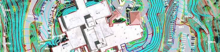
Sample Project:
Project 07043 Park Ridge
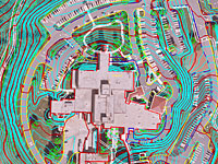 Triangle
Aerial Surveys created topographic and planimetric
mapping for the main hospital site of Fletcher Hospital. Color
photography was flown over the Park Ridge site at a
photo scale of 1”=600’. An accurate
topographic map was essential for the area surrounding
the hospital, including the loop road around the main
building. Planimetric features from the stereo
models were collected including roads, parking lots,
above ground utility locations, drainage, retaining
walls and large trees near the site. Underground
utility locations were included from surveying notes. Features
were presented in a digital file adhering to the mapping
standards for 1”=100’ map scale. Contours
were generated at two foot intervals to show the shape
of the terrain in the project area. Triangle
Aerial Surveys created topographic and planimetric
mapping for the main hospital site of Fletcher Hospital. Color
photography was flown over the Park Ridge site at a
photo scale of 1”=600’. An accurate
topographic map was essential for the area surrounding
the hospital, including the loop road around the main
building. Planimetric features from the stereo
models were collected including roads, parking lots,
above ground utility locations, drainage, retaining
walls and large trees near the site. Underground
utility locations were included from surveying notes. Features
were presented in a digital file adhering to the mapping
standards for 1”=100’ map scale. Contours
were generated at two foot intervals to show the shape
of the terrain in the project area.
|
| |
|
|