| Services
: Photogrammetric |
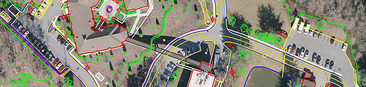
Planimetric Mapping
A planimetric map is a map that represents only the horizontal
positions of features (and not the vertical positions,
like heights, which a topographic map shows).
Sample Project:
| MDOT MA 367-000-002/6 Interstate I-95 Corridor
Mapping -- Baltimore,Maryland |
 |
TAS provided color digital orthophotography,
digital terrain models, topographic and plan sheet
mapping for 1"=40' map scale, 1' contours of about 660
x 19 miles. This project was awarded to TAS by JMT
(Johnson Mirmiran & Thompson) based out of Maryland.
The aerial photography mission was tightly coordinated
to provide unobscured, leaf-off and snow-free ground
visibility during December 2003. The mapping was
prepared at a scale of 1"=100' with 2' contours
and is designed to meet National Map Accuracy Standards
(NMAS), per client request. |
| Photo Scale: |
1”=650’ |
| Control Method: |
Full Control |
| Map Scale: |
1”=100’ |
| Products: |
DTM COMPILATION, 2' NMAS ACCURATE CONTOURS & PLANIMETRIC
DATA |
| Formats: |
.DWG |
| Accuracy: |
NMAS |
|
|
| |
|
|