| Services
: Photogrammetric |
Orthophotography
Digital frame images are ortho-rectified by
a software procedure that uses analytical aerotriangulation
and digital terrain modeling data to reference each pixel
to its precise ground coordinate position. This
process corrects relief displacement within the aerial
imagery. The orthophotos are created to fit the
client’s specifications for ground sample distance
(pixel size) and coordinate system.
Triangle Aerial Surveys provides final orthophoto deliverables in the following
digital formats:
• Tiff with Tiff World file
• GeoTiff
• MrSID
• BIP/BIL/BSQ |
| |
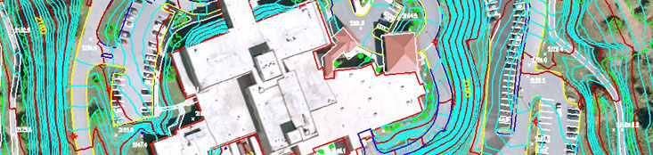
Digital Terrain and Elevation Modeling (DTM
and DEM)
Data sets that represent elevations on the
earth’s surface, DTMs and DEMs are tools instrumental
to the creation of reliable geospatial deliverables
showing an accurate representation of surface features.
Digital
terrain models generally define surface features
in an irregular spacing pattern, using both breaklines
and data points to show abrupt elevation changes
in detail. The result is a more accurate depiction
of the terrain, which is useful for TIN calculations,
generating contours at small intervals, making volumetric
calculations, and ortho-rectifying aerial images. DEMs, though similar to DTMs,
define terrain features in a regular, or grid pattern, so that changes in elevation
are smooth, gradual and less detailed.
DEMs are primarily used in the ortho-rectification
process, GIS applications and the generation of contours
at large intervals. Based upon the requirements of
the client, DTM and DEM data sets can be collected
as part of a larger photogrammetric service or delivered
unto themselves as engineering design tools.
|
| |
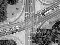
Sample Project:
Project 03043 I-95
 Major
Maryland DOT project to widen highways I-95 and
I-695 North of Baltimore from 4 lanes to 6 each
bound using multiple engineering and construction
firms. Maryland State Highway Administration is
supporting technology improvements in mapping,
drafting and project management. Major
Maryland DOT project to widen highways I-95 and
I-695 North of Baltimore from 4 lanes to 6 each
bound using multiple engineering and construction
firms. Maryland State Highway Administration is
supporting technology improvements in mapping,
drafting and project management.
Mapping requirements
for a 1200' corridor design along highway I-95
involved aerial color photography, using a flight
height of 1200' above ground level, to produce
a map scale of 1” = 40' and developing
a 20' DTM grid to generate 1’ contour interval.
In addition, the aerial photography was used to
produce digital color orthophotography and seamless
orthomosaics. Final products included MicroStation
V-7 and V-8 digital drawing files, georeferenced
orthoimages and various supporting data.
The approximately
nineteen mile project required 220 color images
within 10 flight lines and used 132 ground control
panel points. In addition to normal requirements,
the planimetric drawings included all above-ground
utility data, traffic flow lanes, and supplementary
bridge deck details.
Information
collected and provided by TAS was also used to
perform noise studies, drainage design, volumetric
analysis, earth movement computation and support
Geographic Information Systems analysis.
|
| |
Sample Project:
Project 05001 US 17
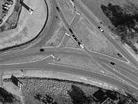 The
project is located along the east coast of South
Carolina between Charleston, SC and Savannah, GA.
Ongoing and intensifying safety concerns have initiated
the project which involves improvements to approximately
22 miles of US 17 from Gardens Corner, SC to Jacksonboro,
SC through the ACE Basin. The project involved
500’ corridor mapping along US 17. Digital
Terrain Models were created at a 25’ grid
along the project area and supported both contour
generation and the rectification of orthophotography. The
project is located along the east coast of South
Carolina between Charleston, SC and Savannah, GA.
Ongoing and intensifying safety concerns have initiated
the project which involves improvements to approximately
22 miles of US 17 from Gardens Corner, SC to Jacksonboro,
SC through the ACE Basin. The project involved
500’ corridor mapping along US 17. Digital
Terrain Models were created at a 25’ grid
along the project area and supported both contour
generation and the rectification of orthophotography.
Duties include:
- • NGS or SCGS control points used
to set control pairs throughout the site using
GPS static surveys
- • Conventional ground survey methods
used to locate edge of pavement, centerline,
and ditches
- • Established horizontal and vertical control
- • Use
topographical information to develop cross sections
at 50-foot intervals on curves and 100-foot intervals
on tangents
- • Public records research of all properties
that might be impacted by the construction of
proposed project
- • Produced a base map in Microstation v8 format
- • Acquired
aerial photography of the mapping area.
- • Produced
photogrammetric design mapping in MicroStation
v8 format.
- • Produced a Digital Terrain Model using
photogrammetric techniques.
- • Produced orthophotography
of the project area.
|
| |
Sample Project:
Project 07050 GADOT
 This
service was provided to the Georgia Department
of Transportation. A corridor of US 27/SR
1 in Rome, Georgia, was to be collected stereoscopically
at a map scale of 1”=50’. Control
points were placed and collected; these points
were then measured along with pass-points to run
the aerotriangulation software and obtain an accurate
solution. Topographic data for the job was
collected 800’ from the centerline each way
along the north portion of the project area heading
into town. The south side of the project
area was collected with an additional 300’ on
each side of the road to ensure sufficient detail. This
service was provided to the Georgia Department
of Transportation. A corridor of US 27/SR
1 in Rome, Georgia, was to be collected stereoscopically
at a map scale of 1”=50’. Control
points were placed and collected; these points
were then measured along with pass-points to run
the aerotriangulation software and obtain an accurate
solution. Topographic data for the job was
collected 800’ from the centerline each way
along the north portion of the project area heading
into town. The south side of the project
area was collected with an additional 300’ on
each side of the road to ensure sufficient detail.
Once
fully collected the compilation was used to create
a DTM for the purpose of ortho rectification. Black
and white photography was rectified using the
DTM with a ground sample distance of ¼ of
a foot. The imagery was formed into a mosaic
and used as an overlay for the compilation as
a method of quality assurance.
|
| |
Sample Project:
Project 08012 PTAA
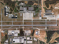 This
is a project of the Piedmont Triad Airport Authority
to support its long-term planning and development
activities. A plotted image showing the immediate
vicinity of the airport is used to record on-going
roadway, parking and runway developments, while
another image, 8.5 feet by 15.5 feet is used to
investigate and demonstrate flight paths and noise
issues. This
is a project of the Piedmont Triad Airport Authority
to support its long-term planning and development
activities. A plotted image showing the immediate
vicinity of the airport is used to record on-going
roadway, parking and runway developments, while
another image, 8.5 feet by 15.5 feet is used to
investigate and demonstrate flight paths and noise
issues.
This 64,000 foot wide by 100,000 foot long
orthophotography project surrounds the Piedmont
Triad Airport in Greensboro with the long axis
parallel with the primary runway. Bare earth LIDAR
data grided to 50 ft was obtained from the North
Carolina Flood Plain Mapping Program. LIDAR data
was used in conjunction with photogrammetrically
collected DTM and breaklines to rectify photography
at 2 foot pixel resolution. Two deliverables were
required, the first being a 20,000 foot by 20,000
foot photo image of the area surrounding the airport
proper, the second deliverable being, a photo mosaic
of the entire area, printed on photo paper and
laminated to preserve the paper and ensure the
accuracy of the print. Fifty six digital color
orthophoto tiles, each 10,000 foot square, were
also produced and delivered on DVD media.
The client
required that TAS provide color aerial photography
using high-resolution, distortion-free, six-inch
focal length camera with forward motion compensation.
The photography was flown at approximately 15,000'
above mean terrain to achieve an approximate photo
scale of 1”=2,500' with 60% forward
overlap and 30% side lap. Four parallel flight
lines of 12 exposures each were acquired, covering
a rectangular area of approximately 12 miles by
19 miles.
|
| |
|
| |
|
|