| Services
: Photogrammetric |
Lidar Mapping and Verification
Emitting laser pulses to measure the distance from an
aircraft to the ground, lidar (Light Detection and Ranging)
collects digital surface data in the form of point clusters.
Lidar data is an effective source of digital elevation
models (DEMs), penetrating into dense vegetation areas
difficult to compile with conventional applications.
Lidar
data is the foundation of intensity images. These
intensity images resemble panchromatic aerial imagery
and can be used for stereo compilation. This technique,
known as Lidargrammetry, is on the cutting-edge of the
field. |
| |
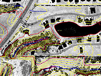
Sample Project:
Oklahoma Wind Farm
 For
the mapping of a wind-power generation site in Oklahoma,
TAS completed the task of compiling planimetric and
breakline data for the generation of 2’ contour
interval. The DEM for the project was provided as lidar
intensity images. TAS collected planimetric features
such as roads, buildings, vegetation, drainage, power
poles and transmission towers. Breaklines and applicable
planimetric features were added to the DEM data for
the generation of contours. The file was converted
to AutoCAD format as per client specifications. For
the mapping of a wind-power generation site in Oklahoma,
TAS completed the task of compiling planimetric and
breakline data for the generation of 2’ contour
interval. The DEM for the project was provided as lidar
intensity images. TAS collected planimetric features
such as roads, buildings, vegetation, drainage, power
poles and transmission towers. Breaklines and applicable
planimetric features were added to the DEM data for
the generation of contours. The file was converted
to AutoCAD format as per client specifications.
|
| |
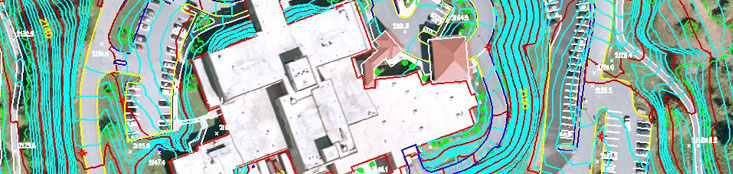
Sample Project:
Harding Ditch Watershed Mapping, East St. Louis Illinois
 As
part of a larger interior drainage study for the Army
Corps of Engineers, Triangle Aerial Surveys participated
in watershed mapping for the Harding Ditch Watershed
in East St. Louis, Illinois. Lidar data was collected
for the entire project area with a grid spacing of
5 feet. This lidar data was then used to create
high resolution intensity imagery for the purposes
of feature collection. All drainage and water
features as well as manmade structures that directly
affect drainage were collected off intensity image
stereo pairs. Breaklines were created to reinforce
the lidar data and provide accurate 2’ contours
for the project. As
part of a larger interior drainage study for the Army
Corps of Engineers, Triangle Aerial Surveys participated
in watershed mapping for the Harding Ditch Watershed
in East St. Louis, Illinois. Lidar data was collected
for the entire project area with a grid spacing of
5 feet. This lidar data was then used to create
high resolution intensity imagery for the purposes
of feature collection. All drainage and water
features as well as manmade structures that directly
affect drainage were collected off intensity image
stereo pairs. Breaklines were created to reinforce
the lidar data and provide accurate 2’ contours
for the project.
|
| |
|
|